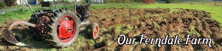

The first pass was the worst; ripping out quack grass, reeds, and all kinds of weeds I can't even identify, was a process.
 After 4 passes, with the last at the deepest tilling setting, I'm really happy with the soil tilth. I only found 3 or 4 rocks in the whole garden (!), and no clay deposits, so that is good. I can tell already that what is really lacking is organic materials. Some manure and compost would go a long way. I am planning on sending off a soil sample to my local extension office for a soil report, which will tell me the current chemical makeup of my soil, which will help me determine what I need to do this year to make the soil healthier for the future.
Before we bought the house I researched the soil composition from this awesome government website. You can zone in on your exact piece of land (at least where I live) and get a full report on the soil in that area.
Here are the results for our 5 acres:
Whatcom County Area, Washington
179—Whatcom silt loam, 3 to 8 percent slopes
Map Unit Setting
- Elevation: 50 to 600 feet
- Mean annual precipitation: 35 to 50 inches
- Mean annual air temperature: 48 to 52 degrees F
- Frost-free period: 150 to 190 days
Map Unit Composition
- Whatcom and similar soils: 85 percent
- Minor components: 8 percent
Description of Whatcom
Setting
- Landform: Hillslopes
- Parent material: Volcanic ash and loess over glaciomarine deposits
Properties and qualities
- Slope: 3 to 8 percent
- Depth to restrictive feature: More than 80 inches
- Drainage class: Moderately well drained
- Capacity of the most limiting layer to transmit water (Ksat): Moderately low to moderately high (0.06 to 0.20 in/hr)
- Depth to water table: About 18 to 36 inches
- Frequency of flooding: None
- Frequency of ponding: None
- Calcium carbonate, maximum content: 5 percent
- Available water capacity: Very high (about 12.7 inches)
Interpretive groups
- Land capability classification (irrigated): 3w
- Land capability (nonirrigated): 3w
Typical profile
- 0 to 9 inches: Silt loam
- 9 to 16 inches: Silt loam
- 16 to 26 inches: Loam
- 26 to 60 inches: Loam"
No comments:
Post a Comment